Tuesday, October 25, 2016

Representations of Space


Space is not an inert, neutral, and pre-existing given, but rather, an on-going production of spatial relations.


This concept, written as such in various publications and attributed to Henri Lefebvre, serves as a foundation for the analysis of the representation of space in urban design.  To define space as a relationship rather than a fixed area in time and space changes the way we may look at representations of conceived space.
 

Though this concept does not provide parameters for what urban design projects may look like, it does help to define the ultimate goal for such projects.  Representations of space are not merely pretty pictures drawn to attract support for a given project, but good representations tell a story that is much larger than a physical setting.

__________________________________________________________________________


Example 1:

Pioneer Courthouse Square in Portland, Oregon, had a long and interesting history throughout its transformations.  Situated in the downtown retail core of the city, the space that came to be known as “Portland’s living room,” was a result of active urban planning intervention to “fulfill cultural, recreational, open space and shelter needs for downtown populations” (Gragg, 2014).  To accomplish this, the Portland Development Commission held a competition in 1980, which was won by a team led by Will Martin.  His ideological framework was thus:


Let the space be ambiguous, fragmented and eternally changing, rich in local symbols and metaphor reflecting Portland’s history as well as bring meaning to citzens of all categories.  We hope to bring together many different meanings to be enjoyed and understood by varying tastes. . .hoping to stimulate discourse between different and often opposed taste groupings with meanings that add up and work together in the deepest combination.  (Will Martin diary, 1980, from Gragg, 2014)


https://aaa.uoregon.edu/100stories/alumni/willard-k-martin
(Gragg, 2014)
 The above drawings are from Martin’s diary with notes discussing his thoughts and process.  While these were personal references, I was attracted to the hand-drawn representations for the warmth and intimate feeling they emanate.  It brings visual storytelling back to its original form and its power cannot be overlooked.  While technology has enabled us to create lifelike representations of our concepts, the hand-drawn image provides meaning that is instantly relatable.

(Gragg, 2014)

This last image shows Martin’s design as he painted it upon the 40,000 square foot parking lot to further solidify public support—a rather creative and ingenious representation of the soon-to-be space.


Example 2:

The following is a block study by urban designer Jacob Dibble for a central neighborhood in Glasgow, Scotland, where a major motorway acted as a division through the community.  This was an academic project with the goal of reconnecting and reintegrating the urban form while keeping true to the historical urban fabric.


http://www.jacobdibble.com/?p=777

The first assessment compares block structure from the past, present and the proposed future.  The next diagram shows the structure form at present and for the proposed future.  The last diagram represents block size, comparing present and proposed block size as well as block size of a bordering neighborhood that functions well.


Together these representations serve to analyze the existing structure of the neighborhood while presenting a proposed solution.  The first two diagrams are easily understood and effective.  Without knowing the neighborhood, one can understand its past and present.  The diagram for the future correlates with the area’s history visually while adding modernity.  The third diagram was conceived mathematically and though visually appealing and indicative of much information, it is hard to understand on initial and second studies.  Dibble’s goal was to highlight the changes the proposed project would induce in the urban tissue.
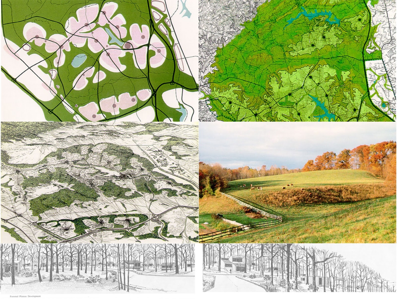


Example 3:

The last example drew me in by the beauty of its images.  A graduate project by Shelley Long at the University of Toronto, her aim is to reimagine the national park system of Canada by way of the Trans-Canada Highway to include the human experience.  Her framework for analysis is Lefebvre’s “The Production of Space,” applied as follows:


The conceived space of designers delineates what is a city, park, or significant landform; the perceived space of imagination contains perceptions of pristine wilderness or idyllic agricultural settings; and the lived or experienced space of users operates at the scale and speed of the highway. These spaces are drawn respectively as layers of measured line drawings, postcards, and aerial/experiential imagery (Long, n.d.).


http://worldlandscapearchitect.com/wilderness-and-exodus-the-production-of-a-national-landscape/#.WA-wR4WcGUn

The representations take the viewer through the historical, natural, and human lived experience of the land.  The concept begins with a broad picture, continues with conceptual background, narrows down to specific sites for design, then returns to the larger area as a reinvented scheme.  The sheer scale of her design is further supported by the spaces left empty on the design sheets.  Conversely, the included snapshots of postcards work to bring the philosophical concept to a generally comprehensible scale.


It is unfortunate that the webpage format does not allow for full understanding because the images are undersized.  With that consideration, and perhaps regardless, the accompanying text (see site link) is necessary.  With a plan based on more abstract thinking, representations supported by description are crucial.

__________________________________________________________________________

These three examples demonstrate different aspects and methods of visual storytelling.  My goal was to explore a broad scope of samplings rather than comparable cases.  The commonality exists in that all exhibit space as a relationship: a historic, situated, pragmatic, evolving concept.  They identify transformations of the past and/or recognize that there are changes yet to come.  As differing as the above examples are, aspects of each help to paint a picture: from age-old pen and paper to scientific digital applications to representational modeling of the land and its metamorphosis.  Each conception creates understanding of a complex system of relationships—which is ultimately the goal of all representations of space in urban design.


If space is a product, our knowledge of it must be expected to reproduce and expound the process of production.  The ‘object’ of interest must be expected to shift from things in space to the actual production of space. . .Thus production process and product present themselves as two inseparable aspects, not as two separable ideas (Lefebvre, 1991).


"Block Study - Jacob Dibble Urban Design." Jacob Dibble Urban Design Block Study Comments. N.p., 2016. http://www.jacobdibble.com/?p=777  Web. 23 Oct. 2016.


Gragg, Randy, and Audrey Alverson. Pioneering the Square. Portland, OR: Portland Spaces, 2014. PDF.


Lefebvre, Henri. The Production of Space. Oxford, OX, UK: Blackwell, 1991. Print.


Long, Shelley. "Wilderness and Exodus: The Production of a National Landscape." World Landscape Architect. N.p., n.d. http://worldlandscapearchitect.com/wilderness-and-exodus-the-production-of-a-national-landscape/#.WA-wR4WcGUn Web. 24 Oct. 2016.


"School of Architecture and Allied Arts." Willard K. Martin. N.p., n.d. https://aaa.uoregon.edu/100stories/alumni/willard-k-martin Web. 23 Oct. 2016.


Tuesday, October 11, 2016

Design, Nature and Influence: Ian McHarg


Ian McHarg
In the introduction to Design with Nature, a book Ian McHarg self-described as his “most powerful identification” (McHarg, 1996, p. 206), Lewis Mumford succinctly sums up the philosophy of his friend and colleague:  “. . . McHarg’s emphasis is not on either design or nature by itself, but upon the preposition with, which implies human cooperation and biological partnership.” (McHarg, 1969, p. viii)

Ian McHarg was not a typical landscape architect, especially for his time.  He was an animated interdisciplinary thinker who was unconcerned about who he might offend.  His way of thinking was guided by a deeply felt connection to nature and an explicit mistrust in human motivations. 

Our failure is that of the Western World and lies in prevailing values.  Show me a man-oriented society in which it is believed that reality exists only because man can perceive it, that the cosmos is a structure erected to support man on its pinnacle, that man exclusively is divine and given dominion over all things, indeed that God is made in the image of man, and I will predict the nature of its cities and their landscapes.  I need not look far for we have seen them—the hot-dog stands, the neon shill, the ticky-tacky houses, dysgenic city and mined landscapes.  This is the image of the anthropomorphic, anthropocentric man; he seeks not unity with nature but conquest.  Yet unity he finally finds, but only when his arrogance and ignorance are stilled and he lies dead under the greensward.  We need this unity to survive (McHarg, 1969, p. 24).

Born in 1920 in Clydebank, Scotland, outside of the industrial city of Glasgow, McHarg grew up viewing the city during the depression era.  Though he describes his home of 18 years as one of “no distinction whatsoever” (McHarg, 1996, p. 14), he emphasizes the distinctive landscape: one which lies on the threshold between town and country.  The years of discovering the beauty of nature juxtaposed with the grimness of the city would influence the rest of his life, and consequently the design profession.

McHarg voluntarily joined the British Army in 1938 and after a distinguished 7-year career as a paratrooper in World War II, the resulting self-confident Major invited Harvard to admit him into the graduate program for Landscape Architecture—an invitation which was accepted.

Obtaining degrees in landscape architecture and city planning after 4 years at Harvard, McHarg returned to Scotland, but was drawn back to the United States in another 4 years.  It was at this time, in 1954, that he accepted a position as founder and chairman of the Department of Landscape Architecture and Regional Planning at the University of Pennsylvania’s Graduate School of Fine Arts.  Besides architects, landscape architects and city planners, the faculty McHarg brought into his department included a geologist, an ethnographer, an anthropologist, a medical anthropologist, a geochemist, a hydrologist, a soil scientist, a plant ecologist, a limnologist and a resource economist (Holden, 1977, pp. 379-380).  In addition to teaching, he also founded a private firm later known as Wallace McHarg Roberts & Todd (WMRT) which designed projects in both the United States and internationally.

WMRT plan for the Valleys (Greenspring & Worthington Valleys, MD), 1964, 
WMRT plan for the Woodlands, TX, located about 28 miles North of Houston.  McHarg was sought out for this project to protect the hydrological system and the woodlands, 1970, http://ladprofile.weebly.com/ian-mcharg-1920-2001.html


It is his book, Design with Nature, that brought him to the forefront of his profession and best describes for what he aspires.  His ecological based planning methods applied to design by superimposing layers of geographical data to reveal relationships which become apparent at spatial intersections to determine suitability for development.  His theories were based on the idea “that nature is a single interacting system and that changes to any part will affect the operation of the whole” (McHarg, 1969, p. 56).  Applying these methods, one can determine that “the lands that best preform work for man in a natural condition will not be those that are most suitable for urbanization. . . . (I)f one selects eight natural features, and ranks them in order of value to the operation of natural process, then that group reversed will constitute a gross order of suitability for urbanization.  These are: surface water, floodplains, marshes, aquifer recharge areas, aquifers, steep slopes, forests and woodlands, unforested land” (McHarg, 1969, p. 154).  While overlaid maps had been used by designers and planners before McHarg, he was the first to use ecology as the organizing structure.  Accordingly, McHarg’s planning methodology is credited with creating the intellectual framework for GIS technology and application (Steiner, 2008, p. 147).

© Ian McHarg, 1969, pp. 105-111.  Staten Island study

Till his death in 2001, McHarg pushed to increase the base of knowledge from which landscape architecture and urban planning drew.  He deplored design for design sake and the transformation of natural systems into artificial systems due to careless urbanization.  In part due to the innovative ideas of McHarg, the concept of designing with nature is no longer new; this is why Ian McHarg is among the most influential urban design thinkers.

“We are of nature, we live in nature.  The appropriate response is to understand its ways and behave accordingly” (McHarg, 1996, p.6).  


Holden, C. (1977). Ian McHarg: Champion for Design with Nature. Science, 195(4276), 379-382. Retrieved October 04, 2016, from http://www.jstor.org/stable/1743286.


McHarg, I. L. (1969). Design with nature. Garden City, NY: Published for the American Museum of Natural History the Natural History Press.

McHarg, I. L. (1996). A quest for life: An autobiography. New York: John Wiley & Sons.

Steiner, F. R. (2008). The Ghost of Ian McHarg. Log, 13(14), 147-151. Retrieved October 04, 2016, from http://www.jstor.org/stable/41765241.